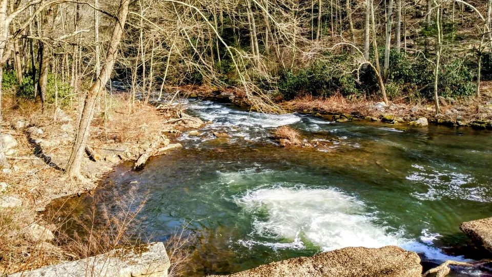
Riffle
Shallow, broken water often signals oxygen and aquatic insect activity.
Guide value $97 FreeRead Maryland outdoors through field guides, outing planning, public lands, and wildlife conflict prevention.
Floodplain term
A stream bottom is the low ground along a stream or creek where water, sediment, shade, roots, and wildlife movement come together. It may include floodplain benches, gravel bars, muddy track traps, sycamore roots, root wads, high-water marks, and shaded corridors.
The term helps readers look beyond the channel. In many Maryland places, the stream bottom is where tracks, feeding sign, plant moisture, and wildlife routes are easiest to connect.

Water-reading card
The channel is only one layer. A useful stream read starts with shade, banks, woody cover, riffles, pools, gravel, and floodplain edges.
Shallow, broken water often signals oxygen and aquatic insect activity.
Deeper slower water can hold fish, turtles, amphibians, and resting cover.
Roots, shade, floodplain, and woody debris often explain the wildlife better than open water.
Read the ground before the water. Look for benches, fresh silt, drift lines, exposed roots, muddy crossings, gravel bars, root wads, fallen logs, animal trails, and where the channel bends against a bank.
Stream bottoms often hold the clearest field sign because mud, sand, and soft leaf litter preserve tracks better than dry uplands.
Spring high water shows floodplain connection and crossing hazards. Summer reveals shade and refuge pools. Autumn leaf drop opens sightlines. Winter exposes nests, tracks, beaver work, and the shape of the bottom.
A stream-bottom page should teach readers how water history remains visible even after the stream has dropped.
Stream bottoms are a high-value internal-link topic because they connect habitats, species, seasons, public lands, and field skills. They also help turn broad stream content into applied observation.
Use stream-bottom language wherever a page needs to explain tracks, banks, floodplain edges, shaded routes, beaver work, otter slides, or safe observation from durable access points.
Written/reviewed by
Michael Deem reviews this stream-bottom guide for field-sign usefulness, safe bank language, and strong connections across stream, wildlife, and season pages.
This page is written to turn a glossary term into usable field judgment, safer observation, and stronger connections between Maryland habitats, species, seasons, and public lands.
Maryland Wilderness review is shaped by current Wildlife Damage Control Operator (WDCO) work through the Maryland DNR Wildlife & Heritage Service framework, ten years of wildlife-conflict experience since 2016, licensed private-applicator experience, practical entomology and pesticide knowledge, nuisance-pattern prevention, insects and attractants, habitat reading, and public education across Maryland wildlife topics.
Open full bioField-skill note
The field-guide pages are most useful when they turn a big outdoor question into a repeatable observation method.
Best use
Tracks, listening, habitat reading, packing, and planning each work better when you keep the exercise simple.
Elite move
A track, call, feather, plant, or trail choice is more useful when time, weather, substrate, season, and place are included.
Common mistake
Better field skill often means holding two or three possibilities until the setting narrows them.
Next step
That moves the guide from reading to field use.
Seasonal review
Season, weather, breeding windows, young wildlife, high water, heat, hunting seasons, closures, and protected-species timing can change what a reader should do next.
Seasonal review refresh: May 7, 2026. Always verify current rules, closures, permits, seasons, and protected-species instructions with Maryland DNR, the county health department, or the official land manager before acting.
Breeding windows, vernal pools, nesting birds, young wildlife, high water, mud season, and bat colony formation can make ordinary field behavior too intrusive.
Heat, storms, ticks, snakes, beach protections, nesting colonies, flightless young, and bat maternity timing should push readers toward shade, distance, and official timing checks.
Migration, mast, rut movement, hunting seasons, bear food pressure, leaf-off visibility, and falling temperatures change both wildlife behavior and public-land use.
Ice, hypothermia, road closures, waterfowl concentration, denning, hibernation, and low daylight require conservative trip planning and no-disturbance wildlife observation.
Guide system trail
Use this path to keep practical guide pages connected to species context, landscape reading, glossary terms, and official rules before an outing.
Term paths
Blue dotted glossary terms open quick definitions. These hubs collect the vocabulary that helps readers find the right department faster.
Interoperable guide system
Use the previous/next links for this department, then jump sideways into the related Maryland Wilderness departments that help explain the same outing, animal, place, or season.